Veteran Drone Training Shifts Toward Survey-Grade Flight Planning
Hiring drones commercially in the U.S. is no longer just a matter of legal qualification to pilot. When it comes to high-value operations such as surveying, LiDAR mapping, and inspecting infrastructure, there is increasing need for personnel that are able to create repeatable and automated missions based on high-quality data and strict workflows.
That is what makes the latest collaboration between SPH Engineering and Vets to Drones meaningful. The program offers access to UgCS Basics training among others to members of a veteran-oriented nonprofit organization. The training is based on UgCS flight planning software created by SPH Engineering. For readers keeping track of the commercial UAS market, the point of interest here is not the partnership announcement itself. It is the rising importance of software-specific certification as a factor that distinguishes candidates for the jobs in surveying, mapping, and inspecting infrastructure.
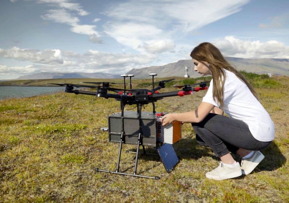
SPH Engineering presents its UgCS software as a platform for creating complex automated flights and high-quality LiDAR data collecting. It claims that the training offered to the members of Vets to Drones is the same one used by enterprise survey teams. It is important to mention since advanced drone operation is now not limited only by pilots’ skills. It includes their ability to create a proper flight path taking into account the terrain, automate data collection, and perform missions with sufficient regularity to support inspection and mapping workflows.
In that sense, this particular training lies between FAA certificate and mission readiness for enterprises. COO of SPH Engineering Alexey Smirnov explained the difference quite literally: “A veteran with an FAA certificate knows how to fly safely, but a veteran who masters UgCS possesses the engineering capability to execute complex, high-value missions that most operators cannot.”
This particular statement reflects the changing nature of commercial UAS work. Drone application in surveying and mapping has already evolved from the experimental period into the stage when aircraft, payload, flight planning software, and data processing are supposed to operate as a unified system. As these workflows evolve, software knowledge becomes easier to test and train for.
For veterans, who are willing to start working in the field, this means that their training will need to go beyond just FAA Part 107. While many programs start with the basics such as FAA certificate preparation, there are still industries like mining, energy, and infrastructure inspecting that demand from applicants the knowledge of the workflow, which allows performing high-quality and precise data collecting.
As CEO of Vets to Drones Chris Lewis stated: “Our mission is to ensure our Nation’s Veterans are completely ready to get hired and excel in using this technology.” Integrating SPH Engineering’s training into the organization’s program was done in order to prepare the members of the organization to the exact technologies that top-tier employers demand.
There is another side of the deal, which has to do with business creation. Veterans completing the UgCS Basics certification will receive 30% discount on core UgCS licenses. This is done to encourage veterans in starting drone services businesses. This is not going to make the technical requirements for professional drone work any lower, but it recognizes a certain reality in professional drone services, software access is a part of the working stack.
SPH Engineering’s product description confirms this point of view. The company calls itself a solution architect in surveying, inspection, and mapping with the use of drones, and the technologies, it offers include not only the software for automated flight but also LiDAR data collecting and even specialized payloads like ground-penetrating radar, magnetometers, and echo sounders. It does not mean that every mission performed by the operators uses them all, but the point remains the commercial value of drones is becoming increasingly dependent on integrated systems rather than just piloting skills.
For the U.S. market, this trend is more significant than ever. Development of the drone workforce is now becoming more specific to certain roles, software, and workflows. Those training programs, which are able to prepare veterans or other entrants for recognizing certain technologies used in surveying and inspecting operations may gain some advantage over training programs that limit themselves with just basic flight skills certification.
Vets to Drones, which is a 501(c)(3) nonprofit organization helping thousands of members to find jobs all over the nation, already provides the opportunity to enter the fields of aerial surveying, infrastructure inspection, thermography, and advanced air mobility. Offering the flight planning training for survey-grade missions improves this pathway in a way that is directly related to the U.S. employers that try to fill the positions in surveying and inspecting.
The commercial drone sector has been spending years proving the value of its aircraft. The next hiring barrier is going to be associated with proving the workflow. This collaboration is a good example of where this barrier is going to be placed on the ability of the operators to perform high-value data missions from safe flights.
By Stephen Wallace — Editor for AMI’s aerospace integration and unmanned mobility coverage, focusing on drone manufacturing, VTOL systems, autonomous networks, and air-ground mobility solutions.