NASA Tracks El Niño With 83% Chance of Strongest Since 1950
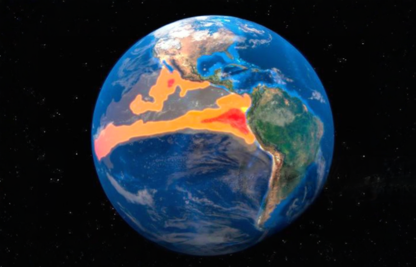
NASA satellites are measuring a major reorganization of the Pacific Ocean as NOAA gives the developing 2026 El Niño an 83% chance of becoming the strongest since 1950. The observations already show warmer surface water, sharply altered sea levels and a decline in the green ocean-color signal associated with phytoplankton.
The probability is still a forecast, not a completed ranking. But the physical changes behind it are visible across multiple satellite instruments, giving scientists complementary measurements of how heat is moving through the ocean and how the marine ecosystem is responding.
The first pulse appeared in January
NASA identified an early signal near Micronesia in January: a Kelvin wave carrying warm water eastward across the equatorial Pacific. These waves transfer heat from the western Pacific toward the Americas and can weaken or reverse the trade winds that ordinarily resist that movement.
Kelvin waves are like the heartbeat of El Niño, said Josh Willis, project scientist for sea-level missions at NASA’s Jet Propulsion Laboratory. And our sea level satellites let us peer into the ocean and watch every beat.
By early April, Kelvin waves had reached the eastern Pacific and sea-surface temperatures were rising. NASA’s satellite radiometers subsequently mapped warmer-than-normal water across millions of square miles, extending from the central Pacific toward South America. Eastern Pacific surface temperatures were about 3 degrees Fahrenheit above the long-term average and could rise further, according to Willis.
El Niño develops roughly every two to seven years. Its signature is warmer-than-normal water in parts of the equatorial Pacific, accompanied by changes in winds, rainfall, ocean heat and sea-surface height. Those connected changes can shift weather patterns far beyond the tropical Pacific, although they do not guarantee a particular storm or seasonal outcome in any one place.
Sentinel-6 measures the ocean’s changing shape
Heat does more than raise water temperature. It also expands seawater, allowing satellite altimeters to track the event through changes in ocean height. In parts of the Pacific, warm-water expansion raised local sea levels by as much as 1 to 1.3 feet. Around Indonesia and northern Australia, sea levels were six to eight inches below normal as warm water shifted eastward.
The Sentinel-6 mission measures water height across the entire ocean every 10 days, with precision down to fractions of an inch. The spacecraft continue a satellite-altimetry record dating to 1993, making it possible to compare the developing event with more than three decades of global sea-level observations.
This is where the satellite architecture earns its value. A temperature map shows where surface warming is concentrated, while altimetry reveals changes in the ocean’s physical shape including heat stored below the immediate surface. The two measurements together provide a more complete view than either can deliver alone.
PACE sees the Pacific become bluer
NASA’s PACE satellite is documenting a different stage of the progression through ocean color. Its Ocean Color Instrument observes several hundred wavelengths across visible, near-infrared and ultraviolet light, allowing researchers to distinguish subtle changes that broad color bands can miss.
Equatorial Pacific waters have become measurably bluer as green hues associated with phytoplankton have weakened. During El Niño, weaker trade winds reduce the upwelling of cool, nutrient-rich deep water. With fewer nutrients reaching the surface, phytoplankton have less food available to support their growth.
The color change therefore records more than appearance. Phytoplankton form a foundation of the marine food web, and a decline can push fish and other marine life toward different feeding grounds. A Food and Agriculture Organization analysis of events from 1950 through 2023 found that strong to extraordinary eastern Pacific El Niños affected fisheries in 11 of 19 major marine fishing areas, with the highest risk in the southeast Pacific.
The 2026 event is the first El Niño observed since PACE launched in 2024. That gives researchers their first opportunity to follow an El Niño-driven biological shift with the mission’s unusually detailed spectral coverage while Sentinel-6 tracks the associated movement of ocean heat.
NASA plans to keep monitoring the event and its effects. The next measurements will show whether the Pacific changes continue toward NOAA’s historic-strength forecast and how far the ocean-color response spreads as the event develops.
| More aerospace and engineering stories, right in your MSN feed. Follow AMI on MSN |
By David Whitaker — Associate editor for AMI’s aerospace and drone systems desk, translating flight systems, aircraft programs, spaceflight, and UAV developments into accessible technical stories.