How NASA’s Iconic Images Map Real Mission Capability
Popularly, the most famous images from NASA have mostly been appreciated in terms of artistic merit. Collectively, though, these images make a useful map of capabilities of various space systems. The reason why the statement above holds is that space image is not just an artwork but also the evidence of platform’s capabilities. Space imagery includes such factors as design, sensors’ location, communications, schedule of operation, workload of the crew and hardware survival in conditions from Low-Earth Orbit to the Outer Solar System.

Crewed operations reveal flexibility, not the scenery
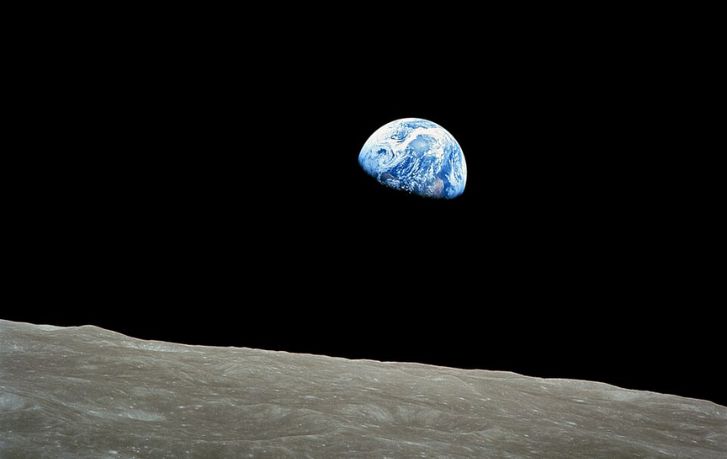
Images of Apollo missions in this list start with William Anders’ famous Earthrise image from Apollo 8 mission, which is known as a perspective of Earth rising above the horizon of the Moon. From an engineering viewpoint, the image indicates a capability of an operationally capable spacecraft to operate in lunar orbit with people on board. Generally speaking, photography has played an important role in NASA’s Apollo program: Hasselblads, adapted for use in pressurized suits and gloves, have been employed to produce space images.
Apollo 11 mission’s pictures are the next step. Visor reflection of Buzz Aldrin with Neil Armstrong and lunar module on the surface of the Moon indicates that there is a working system of the lunar landing, where there is a command module orbiting around, lunar module working on the surface, and cameras that could withstand conditions of the Moon. Additionally, solo flight of Michael Collins on the Command Module and picture of him capturing Eagle approaching the Moon indicate that lunar missions have been distributed systems: separate vehicles with separated responsibilities.
More recent images of the Artemis program also fall under the same scheme with one critical caveat information regarding the timing of the Artemis II mission should be considered carefully unless it has been confirmed by NASA. The main point to note here is the role of Orion’s imagery in demonstration of the capabilities of a contemporary spacecraft able to carry out crewed missions beyond Low-Earth Orbit. As NASA stated, Artemis II mission has been conducted to test performance of Orion’s life support systems, crew interfaces, navigation, reentry systems and manual piloting. Consequently, these images are important in terms of their source the spacecraft that has proved its capability to conduct crewed missions beyond Low-Earth Orbit and not in terms of selfies in weightlessness.
Images of rovers and planetary surfaces represent the mobile science capability
Images of the Martian rovers, depicting dusty landscapes, tracks and rocky surface, may seem obvious; however, they represent the result of operations of a mobile robotic laboratory. On the Martian surface, imagery has served both scientific and operational purposes. Mastcam-Z of the Perseverance rover has been described by NASA as stereo imaging system with zoom capability to conduct detailed examination of distant targets. Additionally, other cameras on the rover have been used to perform driving, placement of the arm and engineering checks. That means that a mere landscape image captured by the rover has indicated multiple capabilities: terrain assessment, navigation, targeting instruments and monitoring the health of the system.
The same can be said about flybys of distant planets. Images of Pluto taken during New Horizons’ flyby in 2015 have not only represented the stunning pictures: they have been the evidence that it is possible to obtain valuable images in a short flyby of a distant body in the Solar System. Images of Jupiter’s Great Red Spot, obtained during Juno’s flybys thousands of miles above the clouds of the giant planet, are the proof that it is possible to survive in a harsh environment of distant planet while obtaining valuable atmospheric images.
Deep space observatories use images to prove their long-term sensing capability
Images of Pillars of Creation and Sombrero Galaxy obtained by Hubble Telescope have belonged to another category of space mission’s capabilities. They do not represent flybys pictures, or crew’s images. These images prove what kind of orbital precision, instrument stability and longevity can be obtained when the space platform is optimized for astronomical observations rather than transport or exploration.
Image of the Earth taken by Voyager 1 during its encounter with our planet in 1990 from almost 4 billion miles away proves how important pointing, data return and mission longevity are in long-distance imagery besides optics. Similarly, famous image of Saturn backlit by the Sun taken by Cassini in 2013 and nicknamed The Day the Earth Smiled has been the result of precise geometry and spacecraft positioning, proving mission’s capability to survive in the deep Saturnian system.
Earth observation images prove the capability of persistent observation
Finally, images from the International Space Station and Earth at night composite prove the capabilities of yet another kind of missions. Images from orbit of the station, taken by astronauts of the cities and auroras during night hours, are the benefit of a platform that returns to Earth and allows a human operator to capture changing conditions regularly. At the same time, Earth at night composite proves the capability of obtaining a bigger picture through stitching of the orbital images.
Bruce McCandless II’s untethered spacewalk in 1984 belongs to the same category of capabilities. Image of Bruce McCandless freely floating in space thanks to his nitrogen-propelled, hand-controlled Manned Maneuvering Unit proves a capability of a crew member to leave spacecraft and perform required tasks.
The general lesson from all of the above is that the famous images of NASA have to be understood in terms of mission outputs, and not milestones. Each of them represents certain capabilities of space platforms: crewed transport, orbital operations, robotic fieldwork, planetary reconnaissance and deep space observation. For aerospace enthusiasts, it is the more exciting side of things: the image is the topmost layer, and the real achievement is underneath.
By David Whitaker – Associate editor for AMI’s aerospace and drone systems desk, translating flight systems, aircraft programs, spaceflight, and UAV developments into accessible technical stories.