Sentinel-6 Tracks Pacific Kelvin Wave as El Niño Builds
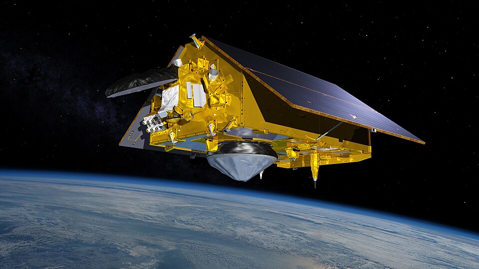
A U.S. associated ocean-observing satellite has revealed insights into how one of the world’s largest climate patterns begins organizing itself in the Pacific. Sentinel-6 Michael Freilich captured sea surface height anomaly readings associated with a large Kelvin wave progressing east through the equatorial region on June 8, which is indicative of a developing El Niño phenomenon.

It is important because this is not solely a temperature issue. Sea surface height is a precise measure that provides scientists information about heat accumulation in the water body, even below the surface. In this instance, the satellite spotted a wide swath of elevated sea surface in the equatorial Pacific. The June map used red to indicate high and blue to denote low levels of sea surfaces compared to normal readings.
The Sentinel-6 Michael Freilich satellite was launched in 2020 by NASA and the European Space Agency under EUMETSAT operations. The spacecraft’s mission may seem highly specialized but easily understandable in essence; it measures changes in the sea surface height in the fractions of an inch on a 10-day basis. In turn, the repeating measurements allow the satellite to become a tool for global monitoring of ocean currents, not an imaging device.
From the perspective of engineers and space enthusiasts, the importance of such measurements lies in the fact that when the ocean heats up, its surface rises due to expansion. This rise becomes visible in relation to both the satellite and the center of the Earth, which makes it possible to track changes in the structure of the ocean caused by heating. In some locations along the equator, sea levels were six inches above average.
Kelvin waves are one of the most obvious cases for explaining why that measuring capability is so useful. These waves form in the western equatorial Pacific in response to weakening of the winds in the region and their reversal for a while. That leads to the formation of warm water in the east, warming of the warm surface layer and suppression of cold upwelling, which usually helps keep Pacific coast of Americas cool. In the case of current wave, it has already reached the shores of South America.
In addition, sea surface height measurements supplement the data obtained from the sea surface temperature measurements. It is the latter that allowed scientists to declare the beginning of El Niño in the central and eastern equatorial Pacific on June 11. However, temperature of the surface is not everything because the height anomalies provide data about the amount of heat accumulated in the upper ocean layer, which makes altimetry missions like Sentinel-6 very useful in early context analysis.
But this year’s June phenomenon did not come out of nowhere because earlier, in January of 2026, the same satellite spotted a Kelvin wave near Micronesia, which dissipated. Another wave occurred in March, which led to elevating sea levels near Peru by mid-May. The process is important because El Niño develops in time as the warm water signals move east and accumulate.
Researchers from NASA have noticed that conditions in western Pacific on June 8 resembled those observed in 1997, the year associated with particularly powerful El Niño. However, there is one crucial factor for comparing this years, which is that in 2026 there were fewer Kelvin waves observed and researchers claim that more observations are needed in order to make a judgment about the strength of the event. As NASA Jet Propulsion Laboratory sea level researcher Severine Fournier explained, “For now, it looks like it’s going to be a big one more so than I would have said last week but we still need more observations to know what’s going to happen.”
The main conclusion for operational users is that ocean altimetry becomes a silent but indispensable part of environmental awareness. The change in the temperature or height of the sea surface can influence the atmosphere circulation patterns, including weather. In the case of El Niño, it can lead to wetter conditions in the southwestern US and less rainfall in the western Pacific. Although Sentinel-6 itself does not forecast the outcomes, it provides the data stream that allows agencies to analyze whether the developing pattern is superficial, temporary or is supported by a larger body of ocean heat.
This is the true importance of Sentinel-6 Michael Freilich. The mission converts the small changes in ocean height into the context about the evolution of Earth system, providing US and international organizations with additional understanding about the mechanics behind the developing El Niño before the full effect will be visible.
By David Whitaker — Associate editor for AMI’s aerospace and drone systems desk, translating flight systems, aircraft programs, spaceflight, and UAV developments into accessible technical stories.