Dramatic Drone Video Captures Volcan de Fuego Erupting Right Before Hikers
High-altitude volcanic monitoring along Central America’s volatile arc has increasingly relied on advanced ‘UAS’ platforms to observe active geologic hazards. Guatemala’s Volcán de Fuego remains among the most relentlessly active stratovolcanoes on Earth, creating an environment where high-altitude mountaineers and aerial sensors operate near violent venting events. The complex tectonic boundary between the Cocos, Caribbean, and North American plates fuels continuous subsurface magma generation throughout the southern Guatemalan highlands.
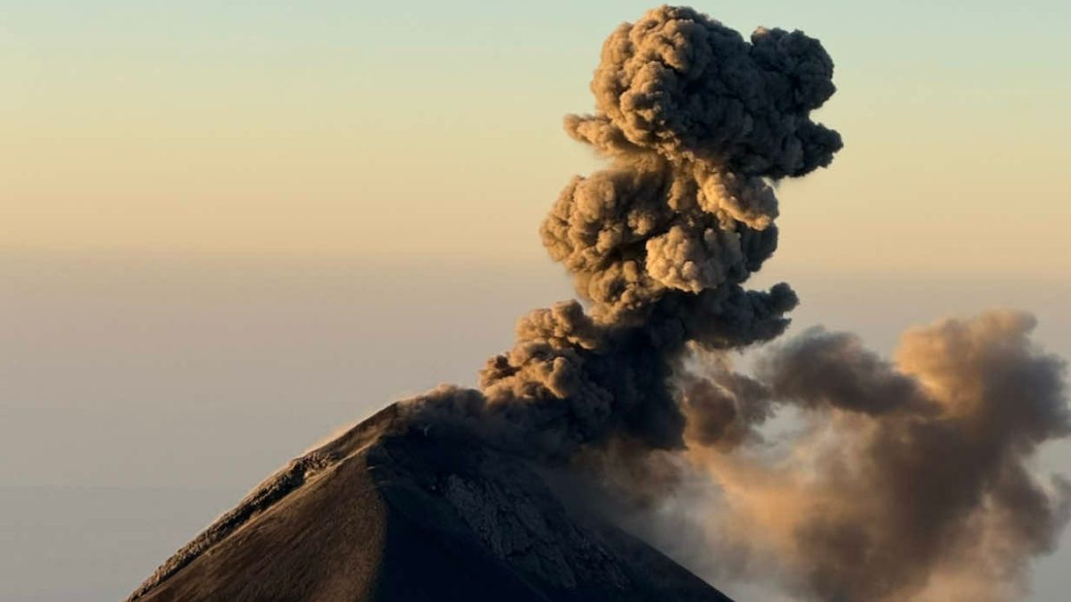
Rising to an elevation of 12,346 feet, the summit continuously expels plumes of hot gas, rock fragments, and ash across the departments of Sacatepéquez and Chimaltenango. While international expeditions routinely navigate adjacent ridges to document these discharges, extreme thermal updrafts and unpredictable ballistic ejections make aerial operations in the immediate airspace exceptionally dangerous. Rapid changes in barometric pressure and high wind shear along the volcanic ridgelines further complicate flight stability for rotary-wing aircraft.
That narrow margin between observation and volcanic hazard was demonstrated in aerial footage published by ABC News, capturing a line of travelers standing along an exposed ridge while a sudden eruption billows directly behind them. The sequence, captured by Mexican photographer and biologist Enrique Barquet and distributed via Storyful, depicts the trekkers transfixed as a dense column of dark ash rises thousands of feet into the sky. Barquet utilized a lightweight quadcopter to frame the hikers against the expanding volcanic plume, providing a rare perspective on human vulnerability during an active summit burst.
The visual asset highlights the expanding intersection of consumer drone technology and extreme adventure tourism in volatile geological sectors. Operating unmanned platforms at elevations exceeding 11,000 feet requires precise flight controls to counteract thin mountain air, which reduces rotor lift and accelerates battery depletion. Fine airborne silicate particles also pose a constant risk of motor fouling, requiring skilled manual piloting to recover the aircraft safely.
Spectacular drone footage captured the moment travelers hiking Guatemala’s Volcan de Fuego watched one of the most active volcanoes in the world erupt earlier this year. https://t.co/aF0wSP6Ap3 https://t.co/2BJYLLT9CB
— ABC News (@ABC) October 26, 2026
Geological records maintained by the Smithsonian Institution’s Global Volcanism Program classify Volcán de Fuego as an open-vent stratovolcano with near-continuous historical activity dating back to 1524. The peak routinely undergoes low-level Strombolian explosions every 15 to 20 minutes, alternating with periodic paroxysmal episodes that generate high-velocity pyroclastic flows. These dynamic events eject basaltic and andesitic material high above the summit crater, presenting a persistent hazard to surrounding communities and transient visitors.
Civil protection authorities under Guatemala’s national disaster coordination agency maintain active surveillance around the mountain, warning that pyroclastic density currents can sweep through drainage ravines at speeds exceeding 50 mph. Despite these severe natural threats, thousands of adventure backpackers traverse the high-altitude saddle connecting neighboring Acatenango each season. Most trekking routes guide participants to designated base camps across the valley, though specialized itineraries venture onto proximate ridges to witness the fiery summit directly.
Deploying small unmanned aerial platforms in such environments allows operators to capture unprecedented views of natural phenomena without placing personnel directly inside lethal blast zones. Barquet’s footage illustrates how compact sensor payloads can document sudden volcanic pulses and terrain interactions that ground-level cameras cannot fully encapsulate. These high-resolution aerial perspectives also provide valuable qualitative data on plume dispersion and wind drift for researchers studying active volcanic conduits.
As commercial drone hardware integrates enhanced satellite positioning, obstacle sensing, and high-wind resistance, civilian and scientific operators are transforming remote environmental monitoring. The footage recorded along Guatemala’s volcanic ridge serves as a testament to the power of modern aerial observation in unforgiving landscapes. By bridging the gap between extreme mountaineering and aerial photography, small unmanned systems continue to reshape how humans observe and document the most volatile forces on Earth.